
Tamaraw Falls: The Waterfall Everyone Passes — but Few Truly Know
Visible from the Puerto Galera–Calapan Road, Tamaraw Falls is a multi-level mountain cascade often treated as a brief photo stop. A closer look shows a changing landscape shaped by geology, rainfall and watershed health — and raises questions about how high it really is and why it bears the island’s iconic name.
Anyone who has travelled between Puerto Galera and Calapan has probably seen Tamaraw Falls. Water tumbles down a steep, forest covered mountainside directly beside the highway. Motorcycles slow down, vans stop for a few minutes, tourists take photographs, and local vendors wait near the road.
For many visitors, Tamaraw Falls is little more than a quick stop during a longer journey.
But the waterfall deserves more attention.
Tamaraw Falls is one of the best known natural landmarks in northern Mindoro. It is part of the mountain landscape that surrounds Puerto Galera, and it shows how closely the town is connected to its forests, rivers, rainfall and watersheds.
It is also an important reminder that Puerto Galera is not only a destination for beaches and diving. Behind the coastline rises a rugged mountain region filled with streams, steep valleys and tropical forest.
Where is Tamaraw Falls
Tamaraw Falls is located in Barangay Villaflor along the main road between Puerto Galera and Calapan in Oriental Mindoro.
It is approximately 13 to 15 kilometres from Puerto Galera town proper. The journey usually takes around 20 to 30 minutes, depending on traffic, weather and the starting point.
Unlike many waterfalls that require a long hike, Tamaraw Falls can be seen directly from the highway. This easy access is one of the main reasons it became such a popular attraction.
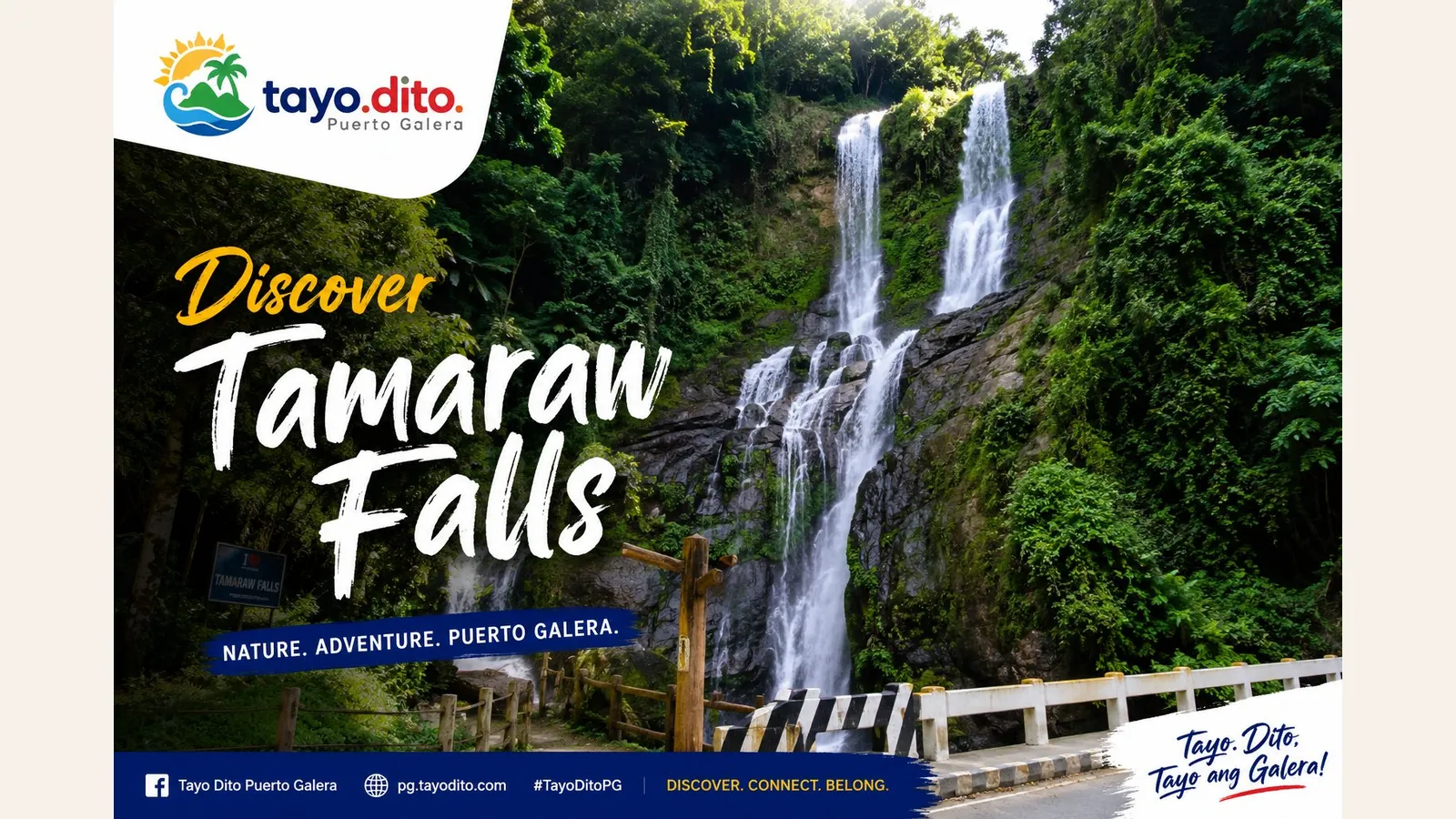
The water descends through several stages over dark rock before continuing below the road into lower streams and pools.
What visitors see is not one simple vertical drop. Tamaraw Falls is a multi level cascade. The stream passes over a series of rock ledges, channels and smaller falls before reaching the bottom.
Its appearance changes throughout the year. During the rainy season, the water can spread across the rock face and form a powerful white cascade. During drier periods, the flow becomes narrower and more of the dark rock becomes visible.
How high is Tamaraw Falls
Many travel websites claim that Tamaraw Falls is 423 feet high, which is around 129 metres.
However, the waterfall visible from the highway does not appear to be one uninterrupted drop of that height. Other descriptions estimate the main visible section at around 20 metres.
The larger number may refer to the total descent of the stream across the mountainside, including upper and lower sections that are partly hidden by vegetation, rocks and the angle of the road.
The smaller measurement probably refers only to the most visible part of the cascade.
Without a detailed professional survey of every section, the exact height should be treated carefully.
The best description is that Tamaraw Falls is a tall, multi level mountain cascade rather than a single vertical waterfall.
It does not need an exaggerated number to be impressive. Its beauty comes from the combination of flowing water, steep rock, dense forest and its dramatic position beside the road.
How the waterfall was formed
Tamaraw Falls exists because of three natural factors.
The first is the steep mountain landscape behind Puerto Galera.
The second is the large amount of rain that falls across northern Mindoro.
The third is the hard rock over which the water flows.
Moist air from the sea is pushed upward by the mountains. As the air rises, it cools and releases rain. The water collects in forest soil, small streams, springs and mountain channels.
Gravity then pulls the water downhill.
Where a stream crosses steep and uneven rock, waterfalls and cascades are created.
Over long periods, water slowly cuts into cracks and weaker sections of the rock. Stones and sand carried by the current scrape against the channel and deepen it. Small pools form below the drops, while harder rock remains as ledges.
This process created the stepped shape of Tamaraw Falls.
The process is still continuing today.
During heavy rain, strong water flow can move loose stones, remove plants, deepen channels and change the appearance of the cascade. The waterfall may look permanent, but it is always being shaped by water.
How old is Tamaraw Falls
It is difficult to give an exact age for the waterfall.
The waterfall itself is much younger than the rocks beneath it. It probably developed gradually as streams carved deeper into the mountain landscape.
Rainfall, erosion, earthquakes, landslides and movements in the ground may all have influenced its formation.
Mindoro has a complex geological history. The island was shaped by the movement and collision of crustal blocks, faults and ancient oceanic material.
Some rock formations found on Mindoro have been linked to geological processes that began hundreds of millions of years ago.
This does not mean Tamaraw Falls itself is hundreds of millions of years old.
It means that the water is flowing across part of a very ancient landscape.
The present waterfall may have developed over thousands or tens of thousands of years, but no reliable study has established a precise age.
Every rainy season continues the same process. Water flows over the rock, carries away small particles and slowly reshapes the mountain.
Why the water flow changes
Tamaraw Falls depends heavily on rainfall.
During the southwest monsoon and during tropical storms, the mountains can receive intense rain. The stream becomes wider, louder and more powerful.
This is often when the waterfall looks most dramatic.
It is also when it can be most dangerous.
Water levels may rise quickly. Rocks become slippery, currents become stronger, and branches or stones may be carried downstream.
The weather beside the road can sometimes appear calm while heavy rain is falling higher in the mountains. Water from that rain may reach the waterfall later and cause a sudden increase in flow.
During the dry season, the waterfall may become much smaller. Some channels may stop flowing, while others continue as narrow streams.
These changes are part of the natural cycle of the waterfall.
They also show the importance of the surrounding forest.
Healthy vegetation helps the ground absorb rainwater. The water is then released more slowly into streams and springs.
When forests are damaged by cutting, construction or erosion, rainwater runs downhill more quickly. This can cause stronger flooding during storms and weaker water flow during dry periods.
Tamaraw Falls is therefore more than a tourist attraction. It is also a visible sign of the condition of the mountain watershed.
Why it is called Tamaraw Falls
The waterfall is named after the tamaraw, the small wild buffalo found only on Mindoro.
The scientific name of the animal is Bubalus mindorensis.
The tamaraw is one of the most important wildlife symbols of Mindoro and one of the most unusual mammals in the Philippines.
Today, the main surviving tamaraw populations are found in protected mountain areas elsewhere on the island, especially around Mounts Iglit Baco Natural Park.
Visitors should not expect to see wild tamaraw around the waterfall.
The name is a tribute to Mindoro and its natural heritage rather than a description of the local wildlife around the site.
The tamaraw represents the island in the same way that other famous animals and landscapes represent different parts of the Philippines.
The name connects the waterfall with Mindoro's identity.
A landmark known long before tourism
Tamaraw Falls was not recently discovered.
Local communities and travellers knew the stream and the waterfall long before Puerto Galera became a major tourism destination.
There is no reliable record naming one person as the discoverer of the falls.
What changed was access.
As the road between Puerto Galera and Calapan improved, more people passed directly beside the waterfall. Drivers began stopping. Tour guides added it to their routes. Vendors appeared near the site.
The waterfall was always there.
The road made it visible to more people.
Its location turned it into one of the easiest natural attractions to visit in the Puerto Galera area.
Its importance to tourism
Puerto Galera is best known for beaches, coral reefs and diving.
Tamaraw Falls offers a different experience.
It introduces visitors to the mountain side of Puerto Galera without requiring a difficult expedition. Families, older travellers and people with limited time can all see the waterfall directly from the road.
It is often included in inland tours together with viewpoints, natural pools, mountain roads and visits to communities outside the main beach areas.
The waterfall also supports local economic activity.
Tour guides, drivers, vendors and small businesses all benefit when visitors stop at the site.
But easy access also creates problems.
Careless parking can block the road. Litter can damage the area. Visitors may climb on wet rocks or enter dangerous water. Too much construction can reduce the natural character of the site.
Tamaraw Falls should be treated as a valuable natural landmark, not only as a background for photographs.
What visitors can do
The most common activity is stopping near the roadside viewpoint and taking photographs.
The main cascade is clearly visible from the road, especially when the water level is strong.
Visitors should park only in a safe area and remember that the Puerto Galera to Calapan Road is an active mountain highway.
Buses, trucks, vans, motorcycles and private vehicles may pass close to pedestrians.
Access to lower pools or swimming areas may depend on current conditions and local management. Rules, entrance fees and operating arrangements may change.
Visitors should check locally before entering any pool.
Natural pools can contain slippery rocks, uneven depths and strong currents. Conditions may change quickly after rain in the mountains.
The safest visit is often the simplest one.
Stop, enjoy the view, take photographs, listen to the water and continue the journey without attempting dangerous climbs.
How to reach Tamaraw Falls
From Puerto Galera town proper, take the main road heading toward Calapan.
The journey normally takes around 20 to 30 minutes.
From White Beach, visitors can travel by tricycle, motorcycle, van or private vehicle. Travel time is usually around 30 to 45 minutes.
From Sabang, the journey may take around 35 to 50 minutes.
From Calapan, the trip usually takes between one hour and one and a half hours, depending on weather, traffic and road conditions.
The road is scenic but winding. Travellers who easily become carsick may wish to prepare before the journey.
Safety at the waterfall
Tamaraw Falls is a natural mountain water system.
It is not a controlled swimming pool or amusement park.
During or after heavy rain, visitors should stay away from fast moving water and avoid climbing wet rocks.
Children should always be closely supervised.
Visitors should follow instructions from local authorities and avoid the area during severe weather warnings, tropical storms or typhoons.
Flash flooding is possible even when the weather at the waterfall seems calm.
When the water is roaring, the best place to enjoy it is from a safe distance.
The best time to visit
The rainy season usually produces the most impressive water flow, but dangerous weather conditions should always be avoided.
The dry season offers calmer travel conditions, although the waterfall may carry less water.
Early morning is often a good time to visit. Temperatures are cooler, traffic may be lighter, and the light can be better for photography.
Late afternoon can also be attractive, but travellers should allow enough time to return before dark.
The mountain road has many curves, and visibility can become difficult at night or during rain.
Why local residents should look again
People who live in Puerto Galera may pass Tamaraw Falls so often that it becomes part of the background.
But the waterfall represents much more than a tourism stop.
It represents the mountains that collect and release water.
It represents the forests that help protect the watershed.
It represents the geological history of Mindoro.
It represents the connection between the coast and the highlands.
It also represents the need to protect the natural resources on which local communities and tourism businesses depend.
The same mountain system that creates the waterfall also feeds streams, springs and other water sources.
Protecting the forest is therefore connected to water security, flood protection and the future of tourism.
A landmark hidden in plain sight
Tamaraw Falls is easy to visit, and that may be the reason many people underestimate it.
It does not require a boat, diving equipment or a long hike.
It stands beside the road, familiar and easy to overlook.
But the water falling over the rocks has travelled through a much larger mountain system.
It has passed through forest soil, springs, cracks and streams before appearing beside the highway.
From there, it continues downhill toward the lower valleys and eventually toward the sea.
Tamaraw Falls is a meeting point between ancient rock and moving water.
It connects the mountains of Mindoro with the tourism life of Puerto Galera.
The next time you pass the waterfall, do not treat it as only another roadside stop.
Pause for a moment.
Look at the mountain above it.
Listen to the water.
And remember that the famous waterfall beside the road is only the visible part of a much larger story.
Tip or correction?
The Tayo Dito team reviews corrections and extra tips before publication.
Comments
0 comments
No comments yet.
Write the first note. It becomes visible after editorial approval.